The Bordelands route by gravel bike
GUADALAJARA - SORIA - ZARAGOZA


. Ruta de Tierras de Frontera Gravel del Camino del Cid (Consorcio del Camino del Cid)")

. Ruta de Tierras de Frontera Gravel del Camino del Cid (Consorcio del Camino del Cid)")


. Ruta de Tierras de Frontera Gravel del Camino del Cid (Consorcio del Camino del Cid)")

 por la ruta cicloturista de carretera del Camino del Cid / ALC.")
, es una de las esculturas más sobresalientes del gótico civil hispánico / ALC.")


. Ruta de Tierras de Frontera Gravel del Camino del Cid (Consorcio del Camino del Cid)")


 tuvo lugar una de las batallas más cruentas del poema entre las tropas del Cid y un ejército llegado de Valencia / ALC.")
 / ALC.")

, de origen árabe / ALC.")


. Ruta de Tierras de Frontera Gravel del Camino del Cid (Consorcio del Camino del Cid)")

The Borderlands route by gravel bike- The Road to Survival: Garrisons, Sieges and Battles
Accompany el Cid and his men through old Islamic frontier territories in the 11th century. Feel like a medieval knight and recreate his fatigues and battles through a rural inland Spain with a natural and scenic diversity that will never cease to amaze you.
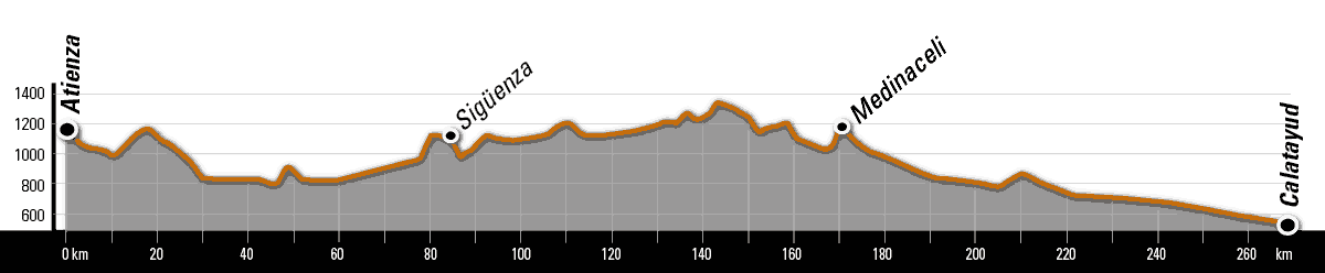
- Route: From Atienza (Guadalajara) - Calatayud (Zaragoza).
- Provinces: Guadalajara, Soria and Zaragoza.
- Kilometres: 268 km approx.
- Recommended days: 3 days
| TECHNICAL DATA | ||
| Distance: 299 km | Cumulative ascent: 4,570 metres | Physical difficulty: Medium |
| Estimated time: 4/5 days | Accumulated descent: 4,270 m | Technical difficulty: Low |
| This is a route designed for gravel bikes and is 100% cyclable, following rural roads with a good surface, comfortable tracks and lonely roads. The route does not offer any significant slopes or significant complications, so you will be able to move at a good pace and enjoy a wide variety of landscapes. | ||
What information about this route you can download on this page
- PDF gravel guide (contains detailed maps)
- The list of accommodation.
- The list of points of issue and stamping of the safe conduct.
- The tourist brochure ( which you can ask for at any of the tourist offices along the route)..
- Guides on: the hiking route, the castles, and the nature of the Camino del Cid as it passes through the province of Zaragoza, published by the Diputación Provincial de Zaragoza.
- The tracks of the route in gpx, kmz and trkformat .
Remember that in the Tourist Offices of the Camino del Cid you can get more information about each route free of charge: including brochures and the safe-conduct.
Download our free travel app
We recommend you download our mobile travel app, available on iOS and Android. The app contains all our routes, you'll never get lost and you'll find information on 4,500 geo-referenced points (Cidian enclaves, places to see, accommodation, pass stamping points, etc.).
The app is free, updated daily and does not require registration. It also works in environments without coverage, so during installation and when you first turn it on, depending on your connection, it may take a few minutes to get it up and running, so be patient, it's worth it!

The plot: In the footsteps of el Cid
Banished by King Alfonso VI, el Cid left Castile and entered the territories of the former Taifa of Toledo by night, so as not to be discovered. This stretch begins in Atienza, by then a Muslim outpost and according to the Cantar a "very strong" rock, and continues towards the Henares, where the exiles, in need of food, take a fortified town, identified as Castejón de Henaresor perhaps Jadraque. At the same time Álvar Fáñez, the lieutenant of el Cid, sets out with two hundred knights to sack the valley; this raid is the plot of the Ramal de Álvar Fáñez. The route continues northwest, crossing the desolate moorland of Layna, towards the Jalón valley, along a route very well described in the Cantar de Mío Cid (Song of My Cid). The Muslim villages that populate its banks, dedicated to agriculture, are forced to support the troops of El Cid.
On the 16th day of the exile, el Cid camped in front of the fortified village of Alcocer (today an archaeological site), very close to Ateca, and after a siege of more than three months he conquered it. In retaliation, an army arriving from Valencia with 3,000 horsemen confronted el Cid and his men. They win in one of the fiercest battles narrated in the Cantar, and the defeated generals are pursued as far as Terrer and Calatayud. With this victory, el Cid increased his fame and wealth, which he needed to continue on his way to Valencia.
This section also includes part of the itineraries followed by Jimena, her daughters and el Cid's host on their journeys to Castile and Valencia; its epicentre is the border fortress of Medinaceli.
The journey: what you will find
Atienza, Guadalajara and Medinaceli were, until the disappearance of the Caliphate at the beginning of the 11th century, enclaves of great importance within the Andalusian Middle Mark: highly militarised posts responsible for the defence of the frontier and for supplying the Andalusian troops, who launched their attacks on the territories colonised by the Christians from there. Between 1085 and 1104 they succumbed to the offensive from León and Castile. Immersed, however, in vast spaces, sparsely populated and frequented by thieves and armed parties of very different origins, they continued to be dangerous places.
At the beginning of the 12th century Medinaceli was the axis separating the Castilian territories from those of the Taifa of Zaragoza, a brilliant Islamic court ruled from 1036 by the Hudi dynasty, of Yemeni origin. The Hudids were patrons of El Cid on more than one occasion and maintained the independence of Saragossa until they were conquered by the Almoravids in 1110. In 1120 the Aragonese King Alfonso I the Battler took Calatayud and the Jalón basin. However, this territory did not lose its frontier character and was the scene of conflicts between the kingdoms of Aragon and Castile.
Proof of this conflictive past can be found in the numerous castles, walled fortifications and watchtowers -of very different periods and state of preservation- that the traveller will find along this stretch of the route. The castles of Atienza, Jadraque, Pelegrina, Sigüenza, Medinaceli, Montuenga de Soria, Monreal de Ariza and, especially, at the end of the journey, Calatayud, one of the most important Islamic walled complexes in Spain, stand out. The route also passes through four towns declared historical and/or artistic sites where it is worth stopping: Atienza, Sigüenza, Medinaceli and Calatayud, as well as small villages with a rural and peaceful atmosphere (only 10 of the 52 towns on this route have more than 400 inhabitants) where you will feel comfortable and safe. As a singular fact, the first examples of Aragonese Mudejar architecture, declared a World Heritage Site, appear along this stretch of the route, in the fertile plains of the Jalón river in Zaragoza.
The route is characterised by its orographic diversity, as it begins in the Serranía de Atienza, at an altitude of 1,320 metres, and ends in the fertile plain of the Jalón, in Calatayud, at 536 metres. The route generally follows the valleys formed by the Henares, Dulce, Tajuña and Jalón rivers, passing through some very spectacular stretches in the form of canyons and narrow valleys, alternating with hypnotic moorlands such as Layna, scrubland and cereal fields. From Medinaceli onwards, the landscape becomes more arid, a true frontier land which, depending on the sections and the time of year, will make you think you are riding through the scenery of a medieval western: extensive plains that give way to a fertile plain, the Jalón, and finally to an almost lunar landscape of gypsum and clay hills, in Calatayud. The route crosses five protected natural areas: the Barranco del Río Dulce ravine, the Parameras de Maranchón and Layna (wide landscapes where you can see a wide variety of steppe birds, including the Dupont's lark), and the savin woods and banks of the Jalón. It is precisely in the section of the Barranco de Río Dulce ravine between Aragosa and Pelegrina, which runs along the bottom of a limestone canyon, where we will find one of the most impressive landscapes of the Camino del Cid, immortalised in numerous recordings by the naturalist Félix Rodríguez de La Fuente.
Culinary delights
The "gastronomic route" begins in the northern mountains of Guadalajara, where you can try roast lamb and roast kid (the best known, that of Jadraque). Traditional cuisine in Guadalajara and Soria offers everything from garlic soup to migas de pastor (shepherd's breadcrumbs) and seasonal dishes such as game and mushrooms. On the banks of the Jalón, the Aragonese tradition and the proximity of the market garden invite us to savour some of its abundant fruit and vegetable products. Here the gastronomy has its epicentre in Calatayud, where the typical dishes are ternasco, the wonderful chickpeas with conger eel or fardeles. The wine of Calatayud, praised by the Roman poet Martial, has evolved a lot: some of the wineries included in this designation of origin offer different wines that will surprise wine lovers. You can finish off your meals with typical sweets, such as the yemas de Sigüenza, the tempting bizcochos borrachos de Guadalajara, or the fruits of Aragon, candied and covered in chocolate, not forgetting the queen of Guadalajara, honey, in any of its varieties and origins.
Layout and signposting
We have designed a route that is 100% adapted for gravel bikes, following rural roads with a good surface, comfortable tracks, asphalted roads and solitary roads. There is no signposting of the gravel route as such, but as it largely coincides with the MTB and hiking routes, you should pay attention to the signposting on these sections.
We recommend that you download the track or the App, and before starting your journey, checkthe Route Alerts box in our map viewer, which shows you the most important incidents you may encounter on the route: high vegetation, interrupted crossings, road works, fallen or missing signs and any other obstacle you need to be warned of.
The roads
Part of the route is on secondary roads with little or no traffic. In any case, do not forget to drive with caution and make yourself visible to vehicles.
Climatology
Continentalised Mediterranean climate, characterised by harsh, cold winters and dry, hot summers. The difference in altitude (from 1,320 m in the Serranía de Atienza to 580 m in Ateca) marks the climatology of each section, making the harshness of winter milder in the lower areas and increasing rainfall in the higher areas (from around 700 mm per year in Atienza to 370 mm in Calatayud). Frosts are frequent in winter, but snowfalls are occasional.
Advice and recommendations
- Length of the stages: ideally, each person should define their stages according to their personal strengths and interests: some people prefer the sporting aspect, the cultural dimension of the trip or the simple sensory pleasure of enjoying landscapes and situations at a leisurely pace. The stages we propose are a mixture of all of these, and are designed so that the average cyclist in stable weather conditions can enjoy the itinerary at their leisure.
- Groceries and spare parts. One of the great attractions of the Camino del Cid is that it runs mostly through very attractive but sparsely populated places: many villages are very small and have no grocery shops. It is very important that, unless you have planned to eat in a bar or restaurant, you carry some food in your saddlebags (sandwiches, nuts, energy bars...) that can help you out of a tight spot. Don't forget to take water with you. There are fountains in most of the villages: don't forget to fill up your tank before leaving them. And the same goes for bike parts: don't forget to take a repair kit with you on the road: the more complete it is, the more relaxed you'll be when you travel. Welcome to the Middle Ages.
- Book your accommodation in advance. You will be travelling through one of the most sparsely populated areas in Europe. Some towns are very small and their infrastructure is limited. Book your accommodation at the end of the stage in advance, and if you change the end of the stage, check that there is accommodation at that point.
- Don't forget to wear a helmet: it is legally compulsory for adults on all road sections outside the city and for children under 16 years of age it is compulsory at all times.
- Get your Salvoconducto. The Salvoconducto is a personalised "passport" that you can stamp in many places along the Camino del Cid. With it you can get discounts of at least 10% in more than 200 accommodations and benefit from promotional offers. It is free and can be requested at any of the more than 70 tourist offices along the route or at the Camino del Cid Consortium.
- Your literary guide. It seems an unnecessary burden, but for many it is an essential guide: don't forget to bring a Cantar de mío Cid; you will be able to recreate some of its passages in situ. If your old Spanish is weak, a modernised edition is preferable!
How to get there... and back
To find out how to get to Atienza click on the information about the town.
Calatayud is an important transport hub. To find out about the different means of transport in Calatayud, click on the information about the municipality.
Rev. ALC: 19.05.2025